- Home
- Product Categories
- GPS Boards
- SparkFun RTK Facet L-Band


SparkFun RTK Facet L-Band
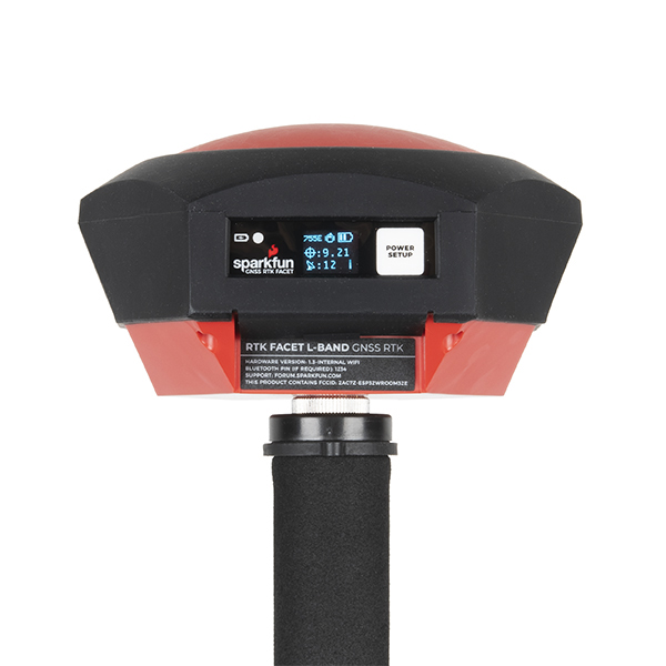
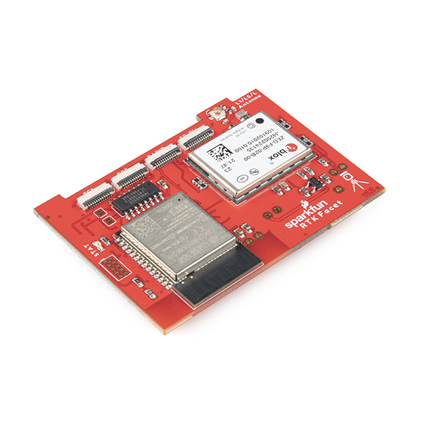
Designed and manufactured in Boulder, Colorado, USA, the SparkFun RTK Facet L-Band is your one-stop shop for high precision geolocation and surveying needs. For basic users, it’s incredibly easy to get up and running; for advanced users, the RTK Facet L-Band is a flexible and powerful tool. With just the press of a button, the RTK Facet L-Band is the fastest way to take centimeter-grade measurements. With built-in corrections, 14mm Real Time Kinematic fixes are less than a minute away. By connecting your phone to the RTK Facet L-Band over Bluetooth®, your phone or tablet can receive the NMEA output and work most GIS software. This is exactly how $10,000 surveying devices have been operating for the past decade - we just made it faster, more precise, and a lot more economical.
The RTK Facet L-Band works with common GIS software for Android and iOS including SW Maps Android / iOS, Field Genius, SurvPC, Survey Master, Vespucci, QGIS, QField, and any GIS software that supports NMEA over Bluetooth.
The RTK Facet L-Band utilizes corrections from u-blox's PointPerfect service broadcast from a geosynchronous Inmarsat satellite. The only setup required is a WiFi SSID and password. Once entered, the device will provision itself and periodically (once a month) update the decryption keys necessary to use the PointPerfect service. The price of the RTK Facet L-Band includes a 12-month subscription. Additional years of service can be purchased.
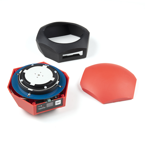
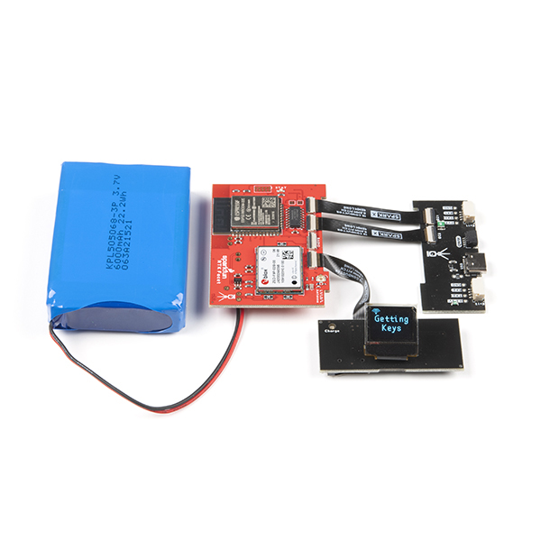
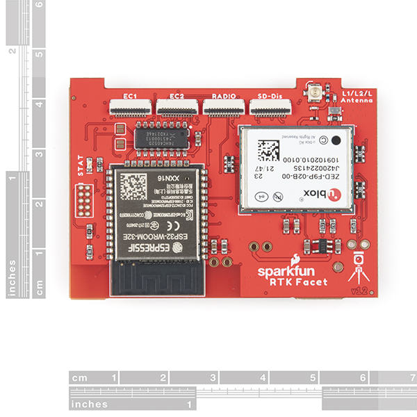
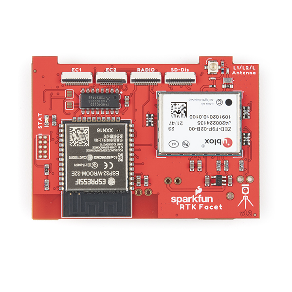
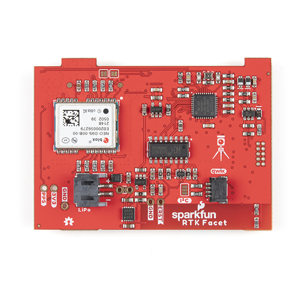
Under the hood of the SparkFun RTK Facet L-Band is an ESP32 WROOM connected to a ZED-F9P GNSS receiver, a NEO-D9S L-Band receiver (for corrections), and a variety of peripheral hardware (LiPo fuel gauge, microSD, etc). Additionally, housed under the dome of the RTK Facet L-Band is a surveyor grade L1/L2/L-Band antenna. This antenna is a unique combination of elements designed to receive the GNSS signals (L1/L2) alongside the 1.55GHz PointPerfect corrections. The built-in antenna has an ARP of 69mm from the base to the measuring point of the L1 antenna and an ARP of 68mm to the measuring point of the L2 antenna. The RTK Facet L-Band is programmed in Arduino and can be tailored by you to fit whatever your needs may be.
This device can be used in five modes:
- GNSS Positioning (~30cm accuracy) - also known as 'Rover'
- GNSS Positioning with RTK L-Band (1.4 to 6cm accuracy) - also known as 'Rover with L-Band RTK Fix'
- GNSS Positioning with RTK (1.4cm accuracy) - also known as 'Rover with RTK Fix'
- GNSS Base Station
- GNSS Base Station NTRIP Server
At Power On the device will enter Rover or Base mode; whichever state the device was in at the last power down. When the POWER/SETUP button is pressed momentarily, a menu is presented to change the RTK Facet L-Band to Rover or Base mode. The display will indicate the change with a small car or flag icon.
In Rover mode the RTK Facet L-Band will check if WiFi is available and update any L-Band keys needed (keys expire every 56 days). The device will automatically begin receiving and decrypting position correction data. Simultaneously, the RTK L-Band will receive L1 and L2 GNSS signals from the four constellations (GPS, GLONASS, Galileo, and BeiDou). The device will calculate the position based on the combination of GNSS and correction signals. The receiver will quickly (within 60 seconds) obtain an RTK float, then fix. Similar to a standard grade GPS receiver, the RTK Facet L-Band will output industry standard NMEA sentences at 4Hz and broadcast them over any paired Bluetooth® device. The end user will need to parse the NMEA sentences using commonly available mobile apps, GIS products, or embedded devices (there are many open source libraries). Unlike standard grade GPS receivers that have 2500mm accuracy, the accuracy in this mode is approximately 14 to 60mm horizontal positional accuracy.
If the device is in Rover mode but L-Band is not available, regular RTCM based RTK is still available. When RTCM correction data is sent over Bluetooth® or into the radio port, the device will automatically enter Positioning with RTK mode. In this mode RTK Facet L-Band will receive L1/L2 signals from the antenna and correction data from a base station. The receiver will quickly (within a second) obtain an RTK float, then fix. The NMEA sentences will have increased accuracy of 14mm horizontal and 10mm vertical accuracy. The RTCM correction data is most easily obtained over the Internet using a free app on your phone (see SW Maps or Lefebure NTRIP) and sent over Bluetooth® to the RTK Facet L-Band but RTCM can also be delivered over an external cellular or radio link to a 2nd RTK Facet, Surveyor, Express, etc setup as a base station.
In Rover mode the RTK Facet L-Band will receive L1 and L2 GNSS signals from the four constellations (GPS, GLONASS, Galileo, and BeiDou) and calculate the position based on these signals. Similar to a standard grade GPS receiver, the RTK Facet L-Band will output industry standard NMEA sentences at 4Hz and broadcast them over any paired Bluetooth® device. The end user will need to parse the NMEA sentences using commonly available mobile apps, GIS products, or embedded devices (there are many open source libraries). Unlike standard grade GPS receivers that have 2500mm accuracy, the accuracy in this mode is approximately 300mm horizontal positional accuracy.
In Base mode the device will enter Base Station mode. This is used when the device is mounted to a fixed position (like a tripod or roof). The RTK Facet L-Band will initiate a survey. After 60 to 120 seconds the survey will complete and the RTK Facet L-Band will begin transmitting RTCM correction data out the radio port. A base is often used in conjunction with a second RTK Facet L-Band (or RTK Surveyor, Express, Express Plus, etc) unit set to 'Rover' to obtain the 14mm accuracy. Said differently, the Base sits still and sends correction data to the Rover so that the Rover can output a really accurate position.
In addition to supplying position data the RTK Facet L-Band is capable of logging NMEA, RAWX, and SFRBX for post processing making it ideal for research and advanced positioning applications.
The RTK Facet L-Band is an open source hardware product meaning you can fully obtain, see, and even modify the electrical and mechanical design files. This allows for easier maintenance and repair over time.
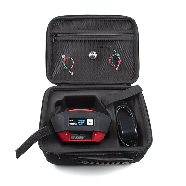
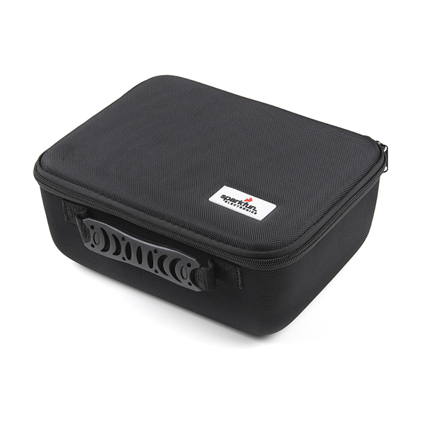
The SparkFun RTK Facet L-Band kit includes everything you need: the enclosed device, correction subscription for 12 months, thread adapter, charger, data cables, and carrying case. It does NOT include a surveying pole. These items will need to be purchased separately.
Please Note: PointPerfect L-Band correction service for the SparkFun Facet L-Band is currently only available in the USA's 48 contiguous states and the European Union shown in the coverage map below. More information on PointPerfect can be found here.

Important: The SparkFun RTK Facet L-Band is not designed for permanent outdoor mounting. Please use the L1/L2 antenna (which we've had outside constantly for over three years in Colorado UV) mounted outside with a cable running to the RTK Surveyor that is located inside or protected from the elements. Or, for a cheaper solution, the ESP32 attached to our ZED-F9P breakout is a great way to go. See our How to Build a DIY GNSS Reference Station tutorial for more information.
Important: The SparkFun RTK Facet L-Band is not designed for permanent outdoor mounting. Please use the L1/L2 antenna (which we've had outside constantly for over three years in Colorado UV) mounted outside with a cable running to the RTK Surveyor that is located inside or protected from the elements. Or, for a cheaper solution, the ESP32 attached to our ZED-F9P breakout is a great way to go. See our How to Build a DIY GNSS Reference Station tutorial for more information.
Supported GIS Data Collector Software:
- SWMaps (Android and iOS)
- Field Genius
- SurvPC
- Survey Master
- Vespucci
- QGIS
- QField
- Any GIS software that uses Bluetooth SPP or BLE
Overall Device
- Enclosed Facet Design IP53 - Protected from limited dust ingress and water spray
- Internal Antenna: L1/L2/L-Band with ≥5dBi gain
- Internal Battery: LiPo 6Ah with fast 1 amp charging
- Radio Port: 3.3V TTL Serial (57600bps RTCM TX/RX)
- Data Port: 3.3V TTL Serial (115200bps NMEA)
- Qwiic Port: Supports I2C based add-on devices
- microSD: Compatible up to 32GB
- Embedded OLED Display for positional accuracy, available satellites, data logging, etc.
- Single push button control
- Weight: 598g (1.3 lbs)
- Dimensions: 136mm x 146mm x 80mm (5.35in x 5.74in x 3.14in)
- Works with common GIS software including: SW Maps, SurvPC, Field Genius, et al.
- Open Source Hardware Certified Project
- Manufactured in Boulder, CO USA
GNSS Receiver: ZED-F9P
- Concurrent reception of GPS, GLONASS, Galileo, and BeiDou
- Receives both L1C/A and L2C bands
- 184-channel u-blox F9 engine
- Current: 68mA - 130mA (varies with constellations and tracking state)
- Time to First Fix: 25s (cold), 2s (hot)
- Max Navigation Rate:
- PVT (basic location over UBX binary protocol) - 25Hz
- RTK - 20Hz
- Raw - 25Hz
- Horizontal Position Accuracy:
- 2.5m without RTK
- 0.010m with RTK
- Max Altitude: 50km (31 miles)
- Max Velocity: 500m/s (1118mph)
Satellite Data Receiver: NEO-D9S
- L-Band data receiver compliance: SESTB28A
- Frequency range: 1525 to 1559MHz
- Sensitivity: 133dBm
- Current: 35 - 130mA (varies during acquisition and tracking state)
- Time to First Frame: <10s
- Receives PMP messages from Inmarsat Geosynchronous Satellites
Bluetooth® Transceiver: ESP32 WROOM
- Xtensa® dual-core 32-bit LX6 microprocessor
- Up to 240MHz clock frequency
- 16MB of flash storage
- 520kB internal SRAM
- Integrated 802.11 BGN WiFi transceiver
- Integrated dual-mode Bluetooth® (classic and BLE)
- Hardware accelerated encryption (AES, SHA2, ECC, RSA-4096)
- 2.5 µA deep sleep current
SparkFun RTK Facet L-Band Product Help and Resources
Core Skill: DIY
Whether it's for assembling a kit, hacking an enclosure, or creating your own parts; the DIY skill is all about knowing how to use tools and the techniques associated with them.
Skill Level: Noob - Basic assembly is required. You may need to provide your own basic tools like a screwdriver, hammer or scissors. Power tools or custom parts are not required. Instructions will be included and easy to follow. Sewing may be required, but only with included patterns.
See all skill levels
Core Skill: Programming
If a board needs code or communicates somehow, you're going to need to know how to program or interface with it. The programming skill is all about communication and code.
Skill Level: Competent - The toolchain for programming is a bit more complex and will examples may not be explicitly provided for you. You will be required to have a fundamental knowledge of programming and be required to provide your own code. You may need to modify existing libraries or code to work with your specific hardware. Sensor and hardware interfaces will be SPI or I2C.
See all skill levels
Core Skill: Electrical Prototyping
If it requires power, you need to know how much, what all the pins do, and how to hook it up. You may need to reference datasheets, schematics, and know the ins and outs of electronics.
Skill Level: Rookie - You may be required to know a bit more about the component, such as orientation, or how to hook it up, in addition to power requirements. You will need to understand polarized components.
See all skill levels
Comments
Looking for answers to technical questions?
We welcome your comments and suggestions below. However, if you are looking for solutions to technical questions please see our Technical Assistance page.
Customer Reviews
3.9 out of 5
Based on 7 ratings:
2 of 2 found this helpful:
Value for money!
This product is wonderful at its price point. I tried the L-Band Correction and I marvel at the accuracy it can deliver without any base unit. No other GNSS receiver on the market that I know of delivers RTK correction via radio, internet, and L-band from a satellite and remains this affordable. Nonetheless, I hope the next gen of this product has an in-built sim card (LTE) as well as an in-built radio. What will even be more orgasmic is having this l-band RTK on survey drones and please add IOS support. I really hope the point-perfect coverage hits Africa.
3 of 3 found this helpful:
Great survey instrument
This is meeting all the expectations that I had when I decided to purchase it. It gets accurate readings with in the 14 mm range. I don't have to set up base station to get those readings.
2 of 2 found this helpful:
Very Nice Device!
It's veryaccurate, compact and easy to use. When will the IOS app become available? We can't use it to it's fullest potential until IOS is available!
1 of 1 found this helpful:
Great device.
Accuracy, price and support excellent… it reduce a lot work.
4 of 5 found this helpful:
Fantastic performance
Everything worked as advertised! Had it set up in a few minutes. Just had to get it connected to a wifi network to download the keys. Once the keys was downloaded, it took about 1-2 minutes and the accuracy was down to an avg. ~14-16mm horizontal accuracy. The unit also supports several ways to extract the 4Hz positioning data using different protocols. Wonderful product!
0 of 2 found this helpful:
Preliminary review
Out of the box it's not doing what the manual and the youtube videos say. There's no instruction on how to connect to WiFi to get the keys and it's not connecting to WiFi to get the keys. The best I am seeing is 1.5ft horiz and vert accuracy. Not cool. Any suggestions on how to access the RTK correction keys would be greatly appreciated. Also, no 'car' icon when I select Rover mode. I have version 2.2 of the firmware and one menu item is 'mark' another is 'bubble' and neither appears to be documented anywhere.
Hi - 1.5ft out of the box is right on the money. To enter your home WiFi credentials please see the Product Manual, section PointPerfect Menu. Once your credentials are entered, you'll obtain keys and L-Band corrections in no time.
0 of 4 found this helpful:
Completely off the mark
The facet L band GNSS has been nothing more than an extremely expensive toy to this point. And most cases it is less accurate than my iPhone. I have a completely clear view of the sky and can only achieveWith any regularity 300 to 500 mm accuracy. The learning curve is rather steep, out of the box this unit is nowhere near ready go. It took two or three weeks researching through the forum to find a possible solution and even begin setting this up. Now I’m outside the return window and likely stuck with this lovely paperweight.
Sorry to hear you are having trouble with your unit. It looks like we sent you a return label on the 16th of January. Your ticket is still open. If you wish to still return the unit, please respond to the support ticket we already have open for you.